

In In the article about Spain, I mentioned the electronic navigation equipment of the yacht for sea passage. One of the readers said, 'It's very interesting how this is all done properly for sailing at sea.'
I will try to describe what electrical equipment was on my yacht and how it was connected. The main idea of a yacht, in my opinion, is to incorporate the maximum of modern technologies necessary for survival in the forces of nature. Such forces include storms, strong winds, rain, cold, humidity, or all of this combined. Therefore, the exterior of the yacht must be strong and sturdy enough to withstand the elements, while the interior should be comfortable for a person to stay in and manage, making the right decisions during natural trials.
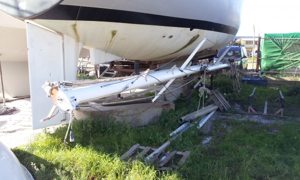
This photo shows the top of the mast. Before the mast is installed on the yacht, which is typically already launched into the water, all necessary equipment is installed on the mast and inside it on land.
Inside the mast, usually run the power cables for the navigation lights at the top of the mast and the anchor signal. In the case of installing a VHF antenna, there’s also the antenna cable and the cable from the weather station. My mast only had a signal and navigation light, while the VHF and GPS antennas were located on the rails at the stern of the yacht. Additionally, active radar reflectors and the radar antennas themselves with corresponding cables are installed inside the mast.
Power supply system
Solar panels are most commonly installed above the spray hood (the mini-tent over the entrance to the cockpit) or on the aft structure.
In the lockers at the stern under the seats in the cockpit, there are batteries. Recently, aviation lithium iron phosphate batteries (LiFePO4, LFP) have become popular among sailors. They are very compact and lightweight. Accordingly, there’s a solar panel controller and a battery charging controller. There’s also an inverter that converts the 12-volt onboard power supply to 19 volts for laptop connection, along with cigarette lighter sockets like in a car.
There is a built-in shore power system at 220 volts. It consists of thermal fuses, regular outlets, and extension cords with universal plugs of two types, which are most popular for connecting yachts to the power network at marinas (during docking). There is also a standard battery charger from the shore power supply.
A stationary diesel engine usually has a generator installed. In older engine models, it is structurally combined with the electric starter of the engine.
Sometimes yachts are equipped with wind generators for cloudy weather (solar panels are ineffective in such conditions) or in case of failure of the diesel generator.
Tools that assist navigation
The most important tool for the skipper is the echo sounder. This device shows, in real time, the actual distance from the yacht's keel to the bottom on a liquid crystal display.
The Doppler hydroacoustic log or forward-looking echo sounder can display not only the absolute speed of the boat relative to the ground but also the features of the terrain ahead of the yacht's bow. This device is not found on all yachts. In particular, it can show fish, dolphins, and whales directly beneath the yacht on the monitor screen.
Older yachts usually have an electromechanical log. It is essentially just a propeller, with its revolutions counted using an electromagnetic sensor.
There is a magnetic compass with electric backlighting.
A weather station that includes, among other equipment, an anemometer to measure wind speed. The station allows for recording both the current wind direction and air pressure.
There is also an emergency navigation tool by stars — a sextant. However, very few sailors know how to use it now since this device has been successfully replaced by GPS receivers. Instead of an emergency sextant, they take a spare handheld GPS powered by batteries. For laptops, a USB GPS is required. It’s good to have multiple GPS devices on a yacht 🙂
Radar is a device that shows obstacles within a radius of several thousand meters, but during inclement weather with rain, its visibility leaves much to be desired. It also cannot detect approaching vessels behind a rock or cape.
More and more people are using AIS at sea. The Automatic Identification System is a digital device that exchanges coordinates and courses of vessels within a radius of 3-4 miles via radio, depending on the transmitter power. This device lacks the shortcomings of radar, but only if all approaching boats are equipped with similar devices, which is far from guaranteed. Additionally, the captain can turn off this device.
Espot and EPIRB (Emergency Position Indicating Radio Beacon), like a satellite phone, allow transmitting information about the yacht's position to the rescue center or simply to the internet from offshore. .
Finally, a very effective tool for obtaining coordinates and a weather forecast in the ocean is a VHF radio station. One must wait for a passing vessel to come into view and request the necessary information via radio. Typically, this includes a weather forecast for the near future and the current coordinates.
About extreme situations
In case of a malfunction or absence of the ship's chronometer, one can request the exact time via radio. However, with the availability of a charged modern mobile phone, almost no one needs this anymore.
A few words about the ship's chronometer. Typically, this consists of mechanical or quartz watches with precise timing placed in a waterproof container made of glass and copper. All this is designed for the temporary immersion of the device in water, in case, God forbid, the yacht capsizes completely around its longitudinal axis (overkill). During a capsize, modern yachts usually lose their mast.
The easiest situation regarding the loss of a yacht's stability is broaching. When it seems that the yacht has laid its mast flat in the water due to waves and wind, it still rights itself thanks to ballast and the balance of forces.
Navigation devices and chart plotters
I like everything about chart plotters that cost 2000 euros, except for the price. If we disregard expensive devices, there are a couple of options to equip the boat similarly but more cheaply.
The first option is to buy a used waterproof and rugged Panasonic Toughpad FZ-M1 or similar tablet (). . And install a yacht navigation OSS program on this tablet. and slightly older electronic marine charts. Alternatively, and preferably, purchase new charts of the region where you are making the passage legally. However, having charts from around the world that are no more than 10 years old can also be useful. The main information remains relevant for navigation.
There is an even cheaper option. The new Raspberry Pi 4 with OpenCPN in (or this one but you will still need to add a radiator, battery, and condensation absorbent.) — 100 euros (or , it has a socket for connecting a battery, or Orange — very cheap).
A similarly protected (IP65 / NEMA4) monitor cost 200 euros (You can assemble a touch monitor that on the screen surface for 145 euros + mounts and waterproof sealant). Water-resistant cables and connectors from China — 30 euros.
The 3-day weather forecast in OpenCPN, with the plugin installed and an Internet connection via WiFi, can download from the weather server. It is important to do this before departure and base decisions on the weather forecast and other factors (the readiness of the vessel and crew) to determine whether to set sail. This decision, considering all factors, affects the safety of the yacht at sea.
You can also build , based on a digital TV reception module for 20 euros (called 'dongles', 'sticks' habr.com/post/149702 habr.com/post/373465), but the sensitivity and reliability of such a device will be questionable. It is better to purchase a specialized device.
Connecting instruments to our navigation device
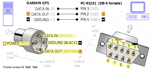
This is a typical schema for connecting a Garmin depth sounder (or any 'slow' instrument) to the navigation system. Clearly, instead of DB-9, USB is used . Please note that all cables and connectors must be waterproof.
A simple electric autopilot
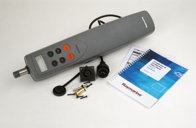
can be connected directly to OpenCPN, like any other yacht instrument. It will keep the course strictly according to your route. However, you will need to monitor the wind changes.
In case of wind change, the weather station will alert you like an alarm, and you will need to re-adjust the sails for another tack.
A modern battery charged during a sunny day by two solar panels will power this device for approximately 8 hours. This will give you a chance to get some sleep. Unfortunately, in a storm, a device of this class is not strong enough to control the yacht. Therefore, you will need a partner or consider installing a more powerful hydraulic device. Alternatively, you could install a mechanical wind steering device.
Microwave
This is a very useful device on a yacht. During a storm, you can hide all sensitive electronics (tablet, mobile phones, laptop) in the microwave. This guarantees the safety of your navigation devices in case of a direct lightning strike on the mast and electrical discharge through the yacht's hull.
Additionally, in the marina, when you connect the microwave to a 220-volt outlet, you can cook food and quickly defrost products.
Source: habr.com
