

From the Translator
Dear Habr users! Since this is my first experiment in publishing content on Habr, please don't judge too harshly. Criticism and suggestions are welcome in DM.
Recently, Google announced the availability of This is one of the most modern data centers, into which companies like Microsoft, Facebook, Apple, Yahoo, and others have invested, located along the line corresponding to the 41st parallel in the United States.
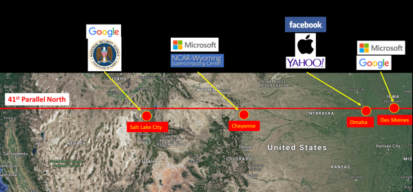
Each of these companies invests billions of dollars in these four cities:
- by Microsoft in one of the largest data centers in Des Moines, Iowa, as well as , located in Cheyenne, Wyoming.
- Apple in a modern data center in Des Moines.
- Google in a data center near Omaha, Nebraska, in addition to a recent investment in Salt Lake City.
- built a supercomputer with a capacity of 1.5 petaflops in Cheyenne, and it is one of the fastest supercomputers in the world.
- The U.S. National Security Agency operates in Salt Lake City, Utah.
So, what makes the 41st parallel so special, prompting various companies to invest billions of dollars in building data centers in these cities?
The answer is that much of the traffic flowing from east to west across the U.S. and back passes through each of these locations via a major assembly of fiber-optic cables owned by several telecom companies, such as AT&T, Verizon, Comcast, Level 3, Zayo, Fibertech, Windstream, and others.
This fiber-optic network infrastructure provides data centers with access to a vast amount of bandwidth, fueling the investment cycle — more data centers attract more traffic, which in turn leads to the construction of more fiber-optic highways, which again results in the establishment of more data centers.
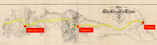
Why did all these telecom giants choose to locate their trunk routes along this path across the U.S.? Because each of these cables runs underground along a continuous 60-meter-wide strip of land, which follows the very first transcontinental railroad, completed in 1869. The U.S. government granted land rights for this area to the Union Pacific railroad, signing . And if you are a telecommunications company looking to lay a new optical trunk through U.S. territory in 2019, you will only need to coordinate your project with one company—Union Pacific. This small strip of land completely crosses the U.S., as depicted in this railroad project from 1864:
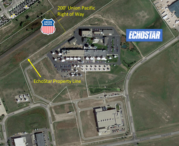
An example of such telecom adjacency is EchoStar's primary teleport in Cheyenne, Wyoming. EchoStar operates 25 geostationary satellites for broadcasting content and films. They purchased a large parcel of land next to the Union Pacific right-of-way, allowing them to connect directly to the transcontinental optical cables buried near the railroad.
In the image below, you can clearly see the line that divides EchoStar's ownership boundaries, with the northern boundary coinciding with the border of the Union Pacific right-of-way.
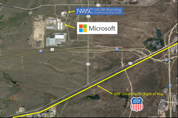
Another example of such adjacency is the Microsoft data centers and the NCAR supercomputing center in Wyoming. Both are located within a kilometer of the Union Pacific railroad:
Why was the railroad built along the 41st parallel, from Iowa to California?
Since 1853, the U.S. has conducted to determine the best route for the new railway — along the 47th, 39th, 35th, and 32nd parallels. In 1859, U.S. Secretary of War Jefferson Davis vigorously supported the southern route from New Orleans to San Diego — it was shorter, there were no high mountains to cross, and no snowfalls that would increase the maintenance costs of the new railway. However, in the 1850s, no congressman from the northern states would vote for a southern route that would benefit the Confederate slave economy, and no congressman from the southern states would vote for a northern route. This deadlock persisted until the onset of the Civil War in the U.S. When the southern states seceded from the Union in 1861, the remaining northern politicians quickly voted to support the Pacific Railroad Act of 1862, which established the starting point of the transcontinental railroad in Council Bluffs, Iowa, and its route — from west to east along the 41st parallel.
Why Council Bluffs? There were many cities eager to compete for the right to gain this privilege. But it was Council Bluffs that was chosen, as the valley of the Platte River just west of the city gradually rose to the Rocky Mountains, providing a convenient water source for steam locomotives. The same water is now used for modern data centers along this route.
After the first railway line was completed, Western Union immediately established the first telecommunication corridor in the railway's right-of-way, and soon was transmitting telegrams from one end of the continent to the other. Later, when AT&T built long-distance telephone lines in the early 20th century, they were also constructed along this railway. These highways expanded and morphed until they transformed into the vast network of communication highways that exists in this stretch of land today.
This is how political decisions made over 150 years ago have today predetermined the location of many billions of dollars invested in modern data centers.
Source: habr.com
